http://students.uwf.edu/cnr12/BobWhite.pptx
http://students.uwf.edu/cnr12/Powerpointsummary.pdf
Wednesday, April 28, 2010
Monday, April 5, 2010


Wednesday, March 31, 2010
Lab 10 (SB Assignment)

The lab went quite well up until I tried to import some road and water shapefiles from Tiger Census information. The layers wouldn't align with the parcel data even after reprojecting them to match projection/coorindate systems with the parcel data. I'm not sure why this kept happening, so I left those layers out of the map. Besides the projection issues (if thats what it was), everything went smoothly.
Monday, March 22, 2010
Week 9 Post

Q1: Which tool did you use? Was there any noticeable difference between its results and the results from the instruction? I tried using the intersect tool. It seemed to work in the exact same way. It combined the features that overlayed the same areas, and it also included the same options for dissolving, joining attributes, etc.. I did not notice any difference between the two results.
Q2: Which tool did you use here? Why? I used the 'erase' tool. It simply cut out the area of the buffers that were overlaying the conservation areas. I used this tool due to its simplicity and efficiency.
Q3: How many features are in this layer? What is the area of the largest feature? What is the area of the smallest feature?
I found 79 features in this layer. Largest area: 7765034 Smallest area: 748
Wednesday, February 24, 2010
Week 7 Lab

Here's my map for lab 7. I don't think I ran into any problems with this activity, although I was not sure what to correct from the blue dots from the lab instructions. My building boundaries look accurate, so I wasn't sure if I was supposed to delete one of those of shift them. Besides that, it was a great lab!
Sunday, February 21, 2010
Week 6 Raster Georeferencing (CR)

Attached is the map for lab 5/week 6. I really enjoyed this lab. I never knew how to georeference and now I have a thorough understanding of it. The main issue I had was with the scale bar/scale text. I do not believe my scale came out correctly.
Wednesday, February 17, 2010
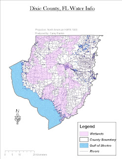
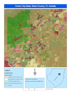
Here are three maps produced for week 5. One map displays wetlands as the main theme, another displays streets, aerials, and landuse, and the third is a combination of an overlaying DEM and DRG dataset.
I had the most trouble with the DEM and DRG raster layers. I couldn't get to match up when using the same projection/coordinate system.

I had the most trouble with the DEM and DRG raster layers. I couldn't get to match up when using the same projection/coordinate system.


Thursday, February 4, 2010

Tuesday, January 26, 2010


Wednesday, January 20, 2010

Monday, January 11, 2010
.jpg)

Wednesday, January 6, 2010
Subscribe to:
Comments (Atom)
